Friday, November 24, 2006

Fish Farm Artefacts


Here are some more finds from beneath the deck boards at the base of the Wheel Pit. Interestingly, there are many 'catches' which are probably Victorian and probably the kind of thing to lift hatches or trap doors which could easily be hatches into what we're now believing to be the trout hatchery. We've found too many of these to ignore them. We've also found two chains as well as some more pots.

One Possible Site Plan


I'm not suggesting this image is true and accurate, it's intended to look at some theoretical possibilities and to follow some reasoning as to "why":
  • we know from written records (rather than drawings) that, at some point there was a 2-stone Corn Mill at Crabble, along side a 'new' 3-stone Corn Mill and, that the two co-existed for some time;
  • if the old remains spanned across the void (beneath the dam) it is unlikely the building would extend very far into this version of the mill. If it wasn't there, why the void space and why build a dam around an inaccessible area?
  • the 2-stone mill would have needed a grain storage space (other than hoppers/bins within the mill) as well as deliveries and also, probably a stable and coach house. Could it be the yellow and/or blue areas? Perhaps these areas were then subsumbed by the increasing business, incorporated in the expansion of the refit and rebuilding of the new Crabble semi-automatic Corn Mill?
I welcome the opportunity to 'walk-through' and discuss the on-site 'tell-tales' with reasonably informed people.

(I've not included the historic fish hatchery/farm in this post.)

THE ... "old painting"


It's interesting and perhaps useful to compare our findings with an old painting. I've zoomed and cropped the image for our observation purposes. How much has the artist used poetic licence and to what extent does it give us more clues:
  1. Is this the inlet point to the old waterwheel and where the old sluice is?
  2. look at the building on the side, or is it the side? If it is the old mill, grain would have to be delivered by horse and cart and flour would have to be taken away.
  3. Is this the present bank surrounding (containing) the old structure which is beneath pond level, or some definition?
  4. There is no platform, governor house, nor extension/annex/door (i.e. todays tea room) to the present watermill;
  5. Therefore, with little definition of the waterwheel on the side of the building, is it actually located there at this point in history?
  6. Is the weir built at this time? Are the watercourses defined as they are today? Which side of the Mill(s) is the main flow of the river Dour actually running?
  7. This is a square building and is similar to the drying kiln which is now house-converted. The other Mill buildings at the weir-side (also now house-converted) on this painting do not appear to have been built yet. Does this enable us to chase a more accurate date for this site-plan and layout?

Answers on a postcard please!!

Thursday, November 23, 2006

Brick Pattern : detail 2


Within these sections, the bricks are less worn, there is substantially less mortar and the bond-type is not commonly known.

Brick Pattern : detail 1


These sections are more worn, some bricks are of differing dimensions, and there is significantly more mortar used which is worn equally to the brick itself. It is laid in the old English bond.

Wheel Pit Brick Patterns


On initial inspection there appears to be two types of mortar and two methods of laying the bricks which are inset in the timber.

Monday, November 13, 2006

Base of Old Wheel Pit


At last!

With the wall and pipe of the fish farm or 'trout hatchery now removed - which we are understanding to be of Victorian times - we can now see the shape and form of the previous
wheel-pit which contained the older millwheel. The profile, the circumference, diametre and other calculations can be made very accurately.

Interestingly, the pink-red brick insets although on the face-of-it may seem the same, the mortar appears different in some sections, and the brick laying is also different. Where there are variances are also some significant signs of wear from water erosion.

Notice that the wooden decking (or slats, or planks) change in the way they are laid, from being lengthways to widthway. The base supporting timber also appears to be more substantial than most of the other timber joists.

Trout Wall or another Red Herring?


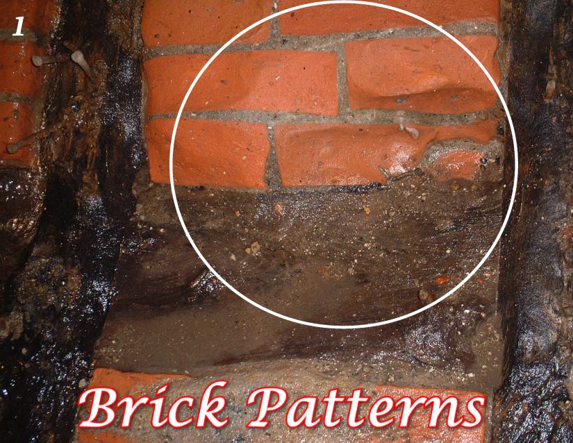
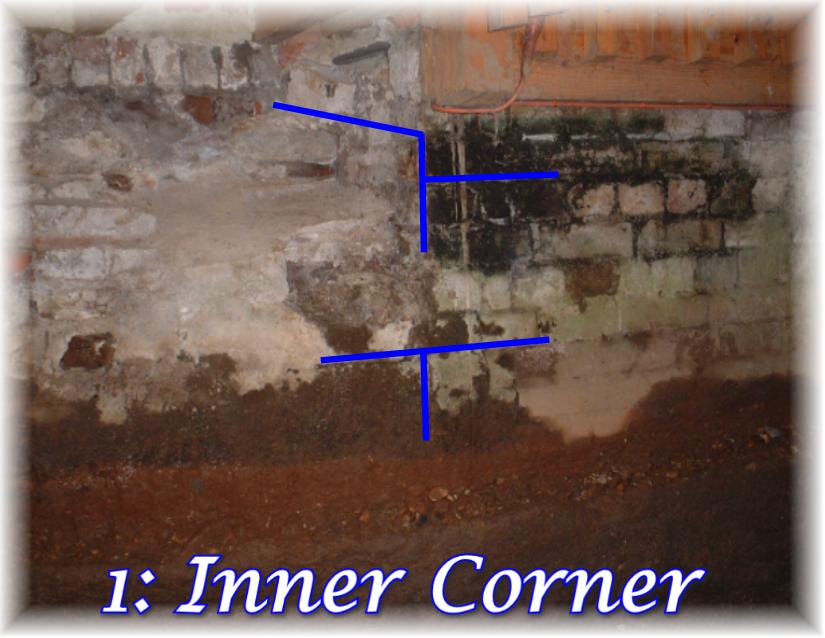
Removing the shallow wall built over the old wheel pit, seems to be one of the most bizarre anomolies yet!

It's looking more and more likely that the purpose of the wall was to contain the fall of water in a little plunge pool, that the pipe cut into the side was to carry most of the flowing water over the 'fish spawning tank' away off site, and the small ledge over this bridge was to allow a small trickling flow of water through the 'tank'.

Whether or not this turns out to be the case, the difficulty in removing the bricks is proving to be one of the most challenging tasks so far. Instead of this badly placed, irregular wall being easily disloged, the bricks and mortar are so hard and bonded together it's as if they are filled with some form of resin which is almost impossible to break. They will not break away with hammer, chisel or cutter. This bonded 'lump', surprisingly is more solid than the concrete plinth previously removed from the other end of the tailrace. This requires nothing less than a kango hammer to chip and break-away fragments, bit by bit.

Naturally, it begs the questions "why, when and for what purpose"?

Whilst the material is very tough, it's also relatively light in weight. This indicates that the bricks are machine made and very pourous, soaking-up whatever the bonding substance has been used.

Apparently, resins have been used for quite some time in recent, contemporary history and are not just a modern item to buy from your local hardware store or builders merchant. Perry, our Kango-man who works on the London Underground, tells us this is not dissimilar to materials found in the foundations of some of the older tracks on the Undergound, some of which date to more than a century old.

More research required!

Old Built Remains 4


This is looking incredibly like the severed base of a stone arch, particularly as a similar broken piece of stonework is on the opposite side of this small tailrace. If so, it would fit well with the concept in being the mid-point between it's (original) 12ft(?) diametre breastshot waterwheel and the corner wall of the previous, smaller mill (which is now in the heart of this Crabble Mill). The proportions seem to 'feel right'.

Interestingly, so far there is very little stone work. Most construction is in brick of varying ages and timberwork along with some chalkblock foundation stones.

Sunday, November 12, 2006

Old Built Remains 3


This line of 'headers' (original top brick course) is working in a smooth downward direction as it gets closer to the exterior, straighter sections of the watercourse. Obviously built very deliberately, has form and function, and is in-tact. I'm informed this curvature in three directions is referred to as "batter".

It's worth noting that these walls seem to be some of the strongest walls in and around Crabble Mill. When we originally restored the Mill, whilst there were leaks and some degree of subsidence elsewhere. This location appears to be very much stable, perhaps some of the oldest on-site.

Old Built Remains 2


Here, at the opposite side of the tailrace is s smaller 90 angle of a walled structure which is in direct alignment with the other. Interestingly, the tailrace wall is anything but crude as the curvature works in two directions i.e. with the curve of the river bed whilst also curving upwards and outwards to contain and guide a large volume of fast flowing water.

If this watercourse had been built just for trout spawning 'tanks', it would probably not require this degree of sophistication to control/contain fast flowing water.

Old Built Remains 1


On top of the older wall of the tailrace is the corner wall of another building within the foundations of this Mill. It turns inward at a 90 degree angle whilst the tailrace continues in a curve away from the Mill. This requires further investigation as it could provide significant clues to the size and shape of the previous mills here.

Tuesday, November 07, 2006

Fish Spawning Troughs


Here's one of several Trout Breeding Troughs .... at least that's what we are led to believe. We inherited a few when we took ownership of the Mill, some of which were made of slate, some made of pottery. Each is a different shape. All have a bottom inlet for water and a top outlet. All were in the river silt of the wheel pit i.e. Zone A.

The reason for inclusion here, is that it could provide a link to previous use of this internal tailrace as a fish spawning bed for trout farming, or perhaps some other clues.

Monday, November 06, 2006

The Pot


This is the most complete pot found so far. Handmade and fired, it was discovered in the base of the wheelpit between the pipe and the lateral wooden beam. The white "X" marks the spot.

Looking foward to archaeologists viewing and analysis.

Zone A(i) - in close-up


1, 2 & 3 are the brick insets which work diagonally, perhaps to a greater depth than the brick base;

4 & 5 are the timber remains attached to the base by hand-forged nails;

6 & 7 are the levels of the more recent cross-wall.

Zone A(i) - Wheel Pit


At the start of zone A, from the curvature of the old waterwheel are different levels which are probably related to different functions:

1. - Wooden cross-beam, probably oak, with long hand-forged rose-head nails;

2. - Old, fragile planking attached to the cross-members beneath;

3. - Brick floor base, resting on river gravels;

4. - Base of small brick wall.

5. - Top of small brick wall.

6. - Three sets of diagonal brickwork which together follow the curvature of the waterwheel deeper;

7. - Two timber insets (shown by arrows) which also follow the deeper curvature;

"X" - is where the pot was discovered.

Friday, November 03, 2006

Orientation Zone F


See Excavation Record. The rock bed and chalk base wall continues. The end inset wall could be recent, it could be older and needs further exploration. Certainly there are metal fixings for 'something'. Another difficult area to work due to getting easily water-logged. However, we probably need to dig another deeper trench across this end point.

Orientation Zone E


See Excavation Record. In this section the timber planking seems to finish although we would not rule out the possibility of it continuing at a lower level. This requires further exploration.

Here is where the change is from river gravels to large chalk rocks, clay/mud along with a change in the side-built structures. This is not what we anticipated and indicates something very different indeed (as previously mentioned).

Orientation Zone D


See Excavation Record. Through here, the deck is neatly constructed to follow the contours of curvature of the tailrace walls and enters the building (even though there was probably no building there at the time of construction, certainly not this mill). All timbers are fixed with handmade nails. Even though we've removed a small yet heavy concrete wall and cut-out metal grills, the floor remains largely in-tact. (We are using scaffold planks to walk on to preserve the floor.)

Orientation Zone C


See Excavation Record. The area with the deck largely in place, set on joist timbers at approx 900ml intervals. The end point has the plank board with slate facing in the inside. This is one of the key signs which suggests a form of tank, thought to be an historic trout hatchery. There are metal fixings in the wall nearby which indicates some other function yet to be determined.

Orientation Zone B


See Excavation Record. This has been one of the hardest areas to work, mainly due to height restriction, but also because of spring perculation. However, a few fragments and artefacts have been uncovered.

Orientation Zone A


See Excavation Record. The area closest to the previous waterwheel. Floor timbers are now fully cleared and exposed and, as well as the small brick wall with the inset pipe (under the footbridge), there are also two small brick pillars further along the area. Close by is a metal fixing in the wall which could possibly hold a pipe.

Where one section of flooring is removed, we believe the bedrock to be about half a metre below and would like to dig a trench here.

The section nearer the waterwheel base is where the greatest amout of metal objects have been found.

Old Tailrace - artefacts 3


Bits of stone jars and other domestic-type containers from recent history. Lots more clay pipes of different periods.

Old Tailrace - artefacts 2


Various creatures small and large, probably relating to different periods. The most curious seems to be oyster shells, simply because there is no obvious reason for them to be here. One idea is that oysters were thought to be part of the staple diet of monks who may have been local. Records exist stating that the monks of St Radigunds Abbey owned a 13th Century watermill somewhere in "crabble". Could it have been here?

Old Tailrace - artefacts 1


In seems the most interesting thing - apart from the volume of fragile timbers and planking - is the amount of slate which is not naturally found locally. It is most likely used as some form of tanking to hold back or contain water. There's also some metalwork which is most probably to do with the workings of an older mill here.

Close to the surface are metal fixings pictured here which are very likely to do with the timber structure/containment area.

Digging, seiving and scanning


James and Ian finishing off the preparations after a hard dig, seiving through the mud and silt, and now finally scanning the area with a metal detector and marking the site.

First Artefacts

With bucket-loads of old handmade nails, bones of dead animals, broken bits of pottery, antique bottles, shells and other things you'd normally expect to find within the river bed of a watermill, all yet to be identified, here's one of the first fragments of several pipes dug out of Zone A.

This one, on first sight appears to be late 1700's.